RTLS technologies out there
RTLS (real-time location system) is a system that reports where tagged people, vehicles, tools, or materials are while they still move. Plants use it for live search, presence at gates, safety zones, path replay, and yard tracking. The pin can come from different technologies. This page surveys the main ones: BLE, RFID, UWB, SLAM, GPS, LoRaWAN, and specialist patterns such as VHF phase ranging and active RFID for RTLS.
BLE: three ways to turn Bluetooth into a floor pin
Bluetooth Low Energy (BLE) is the usual indoor starting point for medium-precision asset tracking. Cheap tags, long battery life, and phones or tablets that already speak the radio. Accuracy is typically in the one-to-three-meter (3–10 ft) band when the hall is honest about metal and coverage. Inside that family there are three common ways to compute position, and they are not interchangeable.
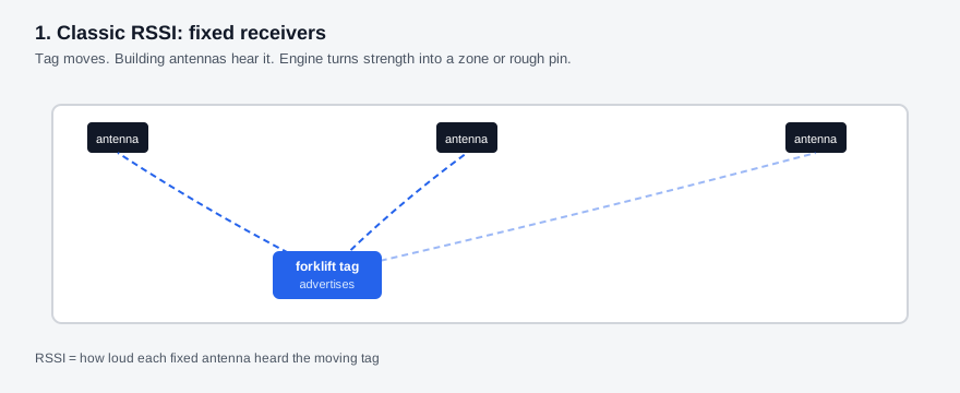
1. Classic RSSI with fixed receivers - Tags or beacons ride on the truck, cage, or badge and advertise. Fixed antennas or locators hear them and score RSSI, the received signal strength. The engine turns those strength samples into a zone or a rough coordinate. This is the textbook BLE RTLS grid: infrastructure on the building, movers carry the cheap radio.
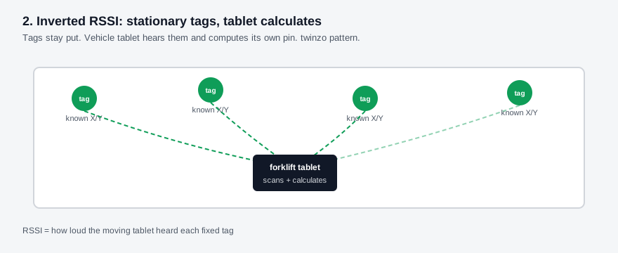
2. Inverted RSSI: stationary tags, mobile calculators - Flip the topology. Cheap tags stay fixed on columns, racks, or ceiling points as known anchors. The forklift tablet (or phone) scans those static beacons, measures RSSI, and calculates its own position on the hall map. The vehicle becomes the locator. That pattern is how twinzo keeps BLE deployments light on dedicated locator hardware and still feeds the same live twin used for internal logistics. Most competing stacks still hang locators on the building and put tags on every mover. The inverted layout is uncommon on industrial floors and is one reason twinzo installations scale with tablets the plant already buys.
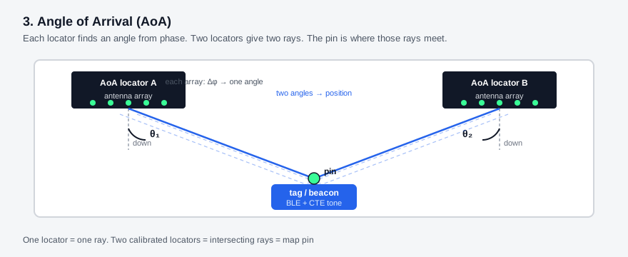
3. Angle of Arrival (AoA) - Bluetooth direction finding (5.1 and later) lets a multi-antenna locator measure the angle of the incoming packet, not only how loud it is. Angle of Arrival (AoA) can push BLE toward sub-meter (~3 ft) pins when the locator array and calibration hold. It still fights 2.4 GHz congestion and metal bounce, but the measurement is different from plain RSSI. Plants that want tighter BLE without jumping to UWB look here first.
Deep dive on all three topologies, diagrams, and device caveats: BLE for RTLS.
RFID: gates, proximity, and live X, Y, Z
RFID is three location builds, sold by different vendors at different price points. A gate is portal antennas at a dock, paint booth, or shipping door. The read says a tagged load passed, the way a shop-exit gate knows you went through. Proximity, including active RFID, says which reader, bay, or station heard the tag. Pair either event with WMS putaway and you close the gap between "scanned at dock 2" and "still sitting in the north buffer" when a zone is enough.
The most advanced RFID build is RFID RTLS that tracks a live position. Antennas mount on the ceiling and report X, Y, and Z while the tag still moves. Many of those installs hold about one metre (~3 ft). That stream sits on the same map as BLE or UWB locations. A portal quote and a ceiling-array quote are not the same project.
Deep dive on the three builds: RFID for RTLS.
UWB when the painted box is the decision
Ultra-wideband (UWB) ranges with short pulses and time of flight, not loudness. Under clean line of sight it can hold sub-meter (~3 ft), often tens of centimeters (~4–12 in). That matters when "near Line 3" is not the same as "inside the painted no-go box." Safety cells, dock-face confirmation, and tight buffer rules are the usual UWB plant jobs.
The trade is denser anchors, shorter tag batteries, and honesty about steel halls. Lab centimeter (inch) claims die under racking. Prove coverage on a short aisle before you scale. For the accuracy split versus BLE, see accuracy floors set by BLE versus UWB and start with the decision, not the technology.
SLAM when the truck carries its own map
SLAM puts cameras, lidar, or an inertial pack on the forklift or AMR. The vehicle builds or matches a map and reports its own pose. No dense ceiling grid for that truck. The pin still lands on the twin next to tagged people and cages. The limit stays honest: SLAM tracks the machine that carries the sensors. The cage on the forks still needs a tag, a scan, an RFID gate, or ceiling-antenna RFID RTLS with a live X, Y, and Z if load identity matters. The recurring cost of tags on fleets belongs on the ROI sheet before you treat SLAM as free of upkeep, covered in what to include when calculating RTLS ROI.
GPS outdoors, LoRaWAN as the pipe
GPS (and the wider GNSS family) works in yards, parking lots, and open sites where the sky is visible. Under a steel roof it does not. Treat GPS as the outdoor layer that hands off to indoor RTLS at the door, not as an indoor miracle.
LoRaWAN is not a positioning radio by itself. It is a long-range, low-power network for sending small packets. Plants and campuses use it to backhaul battery trackers, sensor heartbeats, or rare position updates across large outdoor or mixed sites. The location still comes from GPS, a proprietary module, or another ranging stack. LoRaWAN is the pipe. Confusing the pipe with the pin is how RFQs buy the wrong SKU.
Specialist patterns: VHF phase ranging and active RFID
Not every bid is "BLE or UWB with a dashboard." Two patterns show how far the market stretches. Treat them as radios to recognize in an RFQ, not as a full catalog.
VHF phase ranging runs fixed gateways that broadcast unmodulated VHF carriers (roughly 148–174 MHz, subject to national allocation). Trackers measure phase, separate the direct path from reflections, and compute position on the device. Low frequency penetrates walls better than UWB, so a few gateways can cover a large campus indoors and outdoors. In automotive plant deployments, about 3 m (10 ft) of accuracy is feasible with four VHF antennas plus one private LoRaWAN gateway for about 40,000 m² (about 430,000 ft²). The tracker sends the pin back on that LoRa network, which can push into the plant over Ethernet or LTE (4G / 5G). Those VHF bands are government-controlled, so each country needs an approved frequency range before transmit. The radio story is phase-based VHF ranging, not Bluetooth strength and not UWB pulses.
Active RFID for RTLS is the proximity build: battery tags heard by gateways, either across a long-range cell or against a short-range exciter grid. In the grid layout, exciters sit at known spots and a mobile gateway on a forklift captures the exciter and the tag together, so the plant can say this load is near this anchor. Density sets the location: about 5 m (16 ft) on a close grid, or centimetre-level (inch-level) presence at a workstation. The stack holds up in heavy metallic halls where BLE often struggles. It is a different product and price point from ceiling-antenna RFID RTLS, which reports a live X, Y, and Z.
How teams pick without drowning in radios
1. Name the shift question - Aisle search, coarse zone presence, gate presence, tight safety cell, continuous forklift path, or yard tractor. One question, one accuracy floor. Then pick the family.
2. Separate pin from pipe - GPS, BLE RSSI, AoA, UWB ToF, SLAM, and phase-VHF create the pin. LoRaWAN, 4G, Wi-Fi, and APIs move it. Buy both on purpose.
3. Mix modalities on one map - Halls already run BLE on tuggers, RFID as a gate, a proximity zone, or ceiling antennas with a live X, Y, Z, and UWB only on the painted box. twinzo's job is the shared digital twin and the ops layer on top, from production monitoring to logistics, not a religion about one radio. Definitions start at what is RTLS. Capability depth sits on features.
Each technology above will get its own wiki page later. Use this survey to shortlist what belongs in the next RFQ. Get in touch if you want to walk the same choice on your own facility model.