What is RTLS
A real-time location system (RTLS) reports where tagged people, vehicles, tools, or materials are while they still move. It is a live zone or coordinate, not the last barcode or the last WMS bin.
What RTLS means on the floor
On site, RTLS is a system that reports where tagged people, vehicles, tools, or materials are while they still move. Not the bin someone typed at putaway. Not the station a scanner last saw. A live zone or a live coordinate, updating often enough that a supervisor can send a driver to the right bay instead of starting a hunt. Plants use it for asset tracking that has to stay true during the shift, not only at the next checkpoint.
It is also not GPS for indoors. Satellite signals drop under steel roofs and dense racking. Indoor RTLS uses radios, gate readers, or sensors on the vehicle itself to place the asset on a hall map people already know. That indoor layer is what vendors often call an indoor positioning system. RTLS is the plant name for the same job when the output has to drive a live decision, not a one-off survey.

What last-scan systems do not tell you
Most floors already record location in pieces. A barcode at the dock says the pallet entered. A WMS putaway writes a bin. A MES complete says the job left Station 4. An ERP transfer says the stock moved to a storage location. Those are events. They are true at the moment someone scanned or confirmed. They go stale the second a forklift takes a detour, parks in a buffer, or drops the cage one aisle over because the assigned face was blocked.
That is why empty walks survive in plants that already own warehouse software. Automotive and white-goods halls still lose minutes on “where is the tugger” even when every pallet has an ID, because the ID is not a live pin. WIP cages drift. Returnable stillages sit behind a line that is not theirs. A driver radioed “on the way” can be waiting at a shared aisle. RTLS does not replace those systems. It fills the minutes between their events so the map matches the hall.
Tags, anchors, and a live map
A working RTLS has three parts the floor can point at. Tags or beacons ride on the forklift, badge, cage, or tool and announce who they are. Fixed anchors, locators, or readers sit at known spots in the hall and hear those signals. A location engine turns that radio picture into a position, then a map puts the pin where operators already look: north buffer, dock 2, Line 3 inbound. Without the map, you have a table of coordinates. With the map, a supervisor sees the same hall the driver is standing in.
The radio is not one product. Bluetooth Low Energy (BLE) is the usual zone-level choice. Ultra-wideband (UWB) is the tighter pin. RFID answers presence at a dock door or gate rather than a free-space path. Some trucks carry their own localization with SLAM, so the vehicle maps itself against the layout instead of depending on a dense ceiling grid. Wi-Fi can fill a large zone when the plant already has access points and does not need a tight pin. Yards still use GPS because the sky is open. The mix is normal. One hall can run BLE on tuggers, RFID on shipping doors, and UWB only on the painted no-go box.
What the plant does with the pin is the second half of the system. A live position can stop a search, feed a no-go rule, rebuild a spaghetti path, or show dwell in a blocked buffer. None of that happens if the team only stores coordinates in a historian nobody opens during the shift.
Location accuracy is the decision that matters
Accuracy is not a brochure number you maximize. It is how wrong the pin can be before the next action fails. Zone search only needs to know the vehicle is in this bay or this aisle. A one-to-three-meter BLE reading is enough to kill a five-minute walk. The last meters are still covered on foot. Safety lockouts and dock-face confirmation need a tighter floor. Sub-meter UWB starts to matter when “near the line” is not the same as “inside the painted box.” RFID is honest about a different job: it tells you the tagged load passed this door. It will not draw the path through the hall.
Indoor GPS is the trap in a lot of first meetings. It works in the yard. Under a metal roof it does not. Buying a tighter radio than the decision needs also has a cost: more anchors, shorter tag batteries, denser calibration. The companion pages on this wiki walk that split in more detail, from starting with the decision, not the radio to the accuracy floors set by BLE versus UWB. The graph below is the plant version of the same choice.
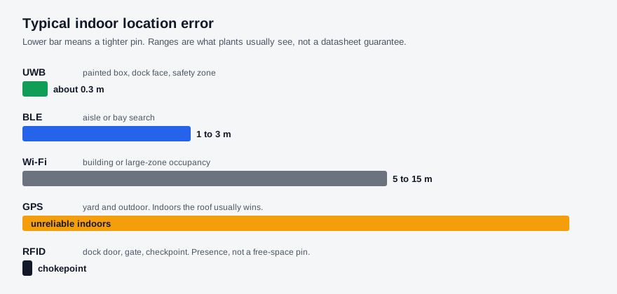
Metal racking, moving forklifts, and concrete walls bounce radio. A vendor who quotes centimeter accuracy from an empty lab is not quoting your Hall B. Treat the ranges as what a maintained industrial install usually holds, then prove them on a short aisle before you scale the grid.
How plant teams choose a system
1. Name the question this quarter will enforce - If the fight is “which aisle holds the last pallet of that SKU,” zone-level BLE or a sparse tag plan is the honest start. If the fight is “did that truck enter the pedestrian box,” the zone geometry itself sets the radio. Do not buy UWB for a search problem, and do not ask BLE to certify a two-meter safety cell.
2. Separate presence from path - Dock confirmation, shipping-door control, and cage hand-off often need RFID or a reader at a known point. Continuous forklift paths, empty-round analysis, and live search need a stream that updates while the vehicle moves. Mixing those two jobs into one hardware SKU is how plants overpay for gates they could have scanned, or under-instrument halls they expected to map.
3. Put the pin on a hall people already trust - Coordinates in a table still force a translation step. The operational picture that logistics and production will actually use is a live digital twin, the same layer described under types of digital twins. If the map does not match the columns and doors on the floor, the RTLS project becomes another screen nobody opens.
4. Own the tags like you own radios - Batteries, mounting, and lost badges are part of the system. A cheap tag that dies every quarter will quietly turn the map into last week's guess. Match update rate to the decision: search can ping slower than a safety zone.
Once the position sits on a live twin
This is where twinzo sits after the concept is clear. The product job is not a second location vendor. It is the live hall view that can ingest BLE, UWB, RFID, SLAM, or the systems you already run, then put those pins next to material state and production signals. Logistics uses that picture for internal logistics optimization. Supervisors use the same model for production monitoring when a line is waiting on a kit that left the dock late. Capability detail lives on the features overview. A longer primer on radio mix lives in getting started with RTLS.
The concept to lock first is simpler than the stack. RTLS answers where the tagged thing is now, at the accuracy the next action needs, on a map the shift already understands. Buy that. Then let the twin carry the pin into the jobs the dock already owns.
Get in touch if you want to walk the same location question on your own facility model.